


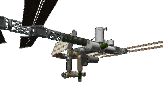


Overview of Earth‑orbiting Satellites
Satellites are artificial objects placed in orbit around Earth for a wide range of functions.
They are launched into specific orbital regimes—Low Earth Orbit (LEO), Medium Earth Orbit (MEO), Geostationary Orbit (GEO), and Highly Elliptical Orbit (HEO)—each offering distinct advantages for particular applications.
Major Categories and Typical Uses
CATEGORYTYPICAL ALTITUDEKEY CHARACTERISTICSPRIMARY USES
LEO160 km – 2 000 kmShort orbital period (~90 min), low latency, frequent passes over a given locationEarth observation, remote sensing, scientific research, communications constellations (e.g., Starlink, OneWeb)
MEO2 000 km – 35 786 kmStable orbits, often used for navigation constellationsGlobal navigation satellite systems (GPS, GLONASS, Galileo, BeiDou)
GEO~35 786 km (geostationary)Matches Earth’s rotation, appears stationary over a point, large coverage areaWeather monitoring, TV broadcasting, broadband internet, military communications
HEO (incl. Molniya, Tundra)Highly elliptical, apogee up to ~40 000 kmLong dwell time over high latitudes, high inclinationCommunications for polar regions, early‑warning missile detection, scientific missions
Specific Applications
Earth Observation & Remote Sensing
Imaging satellites (e.g., Landsat, Sentinel) capture multispectral photos for agriculture, forestry, disaster response, and climate monitoring.
Radar satellites (e.g., Sentinel‑1) use synthetic‑aperture radar to see through clouds and at night, useful for flood mapping and ice monitoring.
Navigation & Timing
Constellations such as GPS (USA), GLONASS (Russia), Galileo (EU), and BeiDou (China) provide precise positioning, timing, and velocity data for smartphones, aviation, maritime, and autonomous vehicles.
Communications
Geostationary satellites (e.g., Intelsat, SES) deliver TV, radio, and broadband to large regions.
LEO constellations (e.g., SpaceX Starlink, OneWeb) offer low‑latency internet, especially in underserved or remote areas.
Scientific Research
Space telescopes (e.g., Hubble, James Webb) operate in LEO or Lagrange points to observe the universe.
Atmospheric satellites (e.g., TIMED, COSMIC) study ionospheric and climate processes.
Defense & Security
Reconnaissance satellites provide high‑resolution imagery for intelligence.
Early‑warning satellites in HEO detect missile launches and track ballistic trajectories.
Navigation‑Assisted Services
Augmentation systems (e.g., WAAS, EGNOS) use GEO satellites to improve GPS accuracy for aviation and precision agriculture.
How Satellites Operate
Launch & Deployment – Rockets place the satellite into its target orbit; deployment mechanisms release it from the launch vehicle.
Orbit Insertion & Station‑keeping – Onboard thrusters adjust the orbit and maintain position against atmospheric drag and gravitational perturbations.
Power & Communication – Solar panels generate electricity; batteries store energy for eclipse periods. Radio transceivers transmit data to ground stations or relay via other satellites.
Payload Function – Sensors, antennas, or other instruments perform the mission‑specific tasks (imaging, signal relay, etc.).
Future Trends
Mega‑constellations: Hundreds to thousands of LEO satellites will expand global broadband coverage and enable new services like low‑latency edge computing.
On‑orbit Servicing: Planned missions aim to refuel, repair, or upgrade satellites, extending their lifespans.
Small‑sat Platforms: CubeSats and nanosatellites lower launch costs, fostering rapid innovation and university‑level space research.